

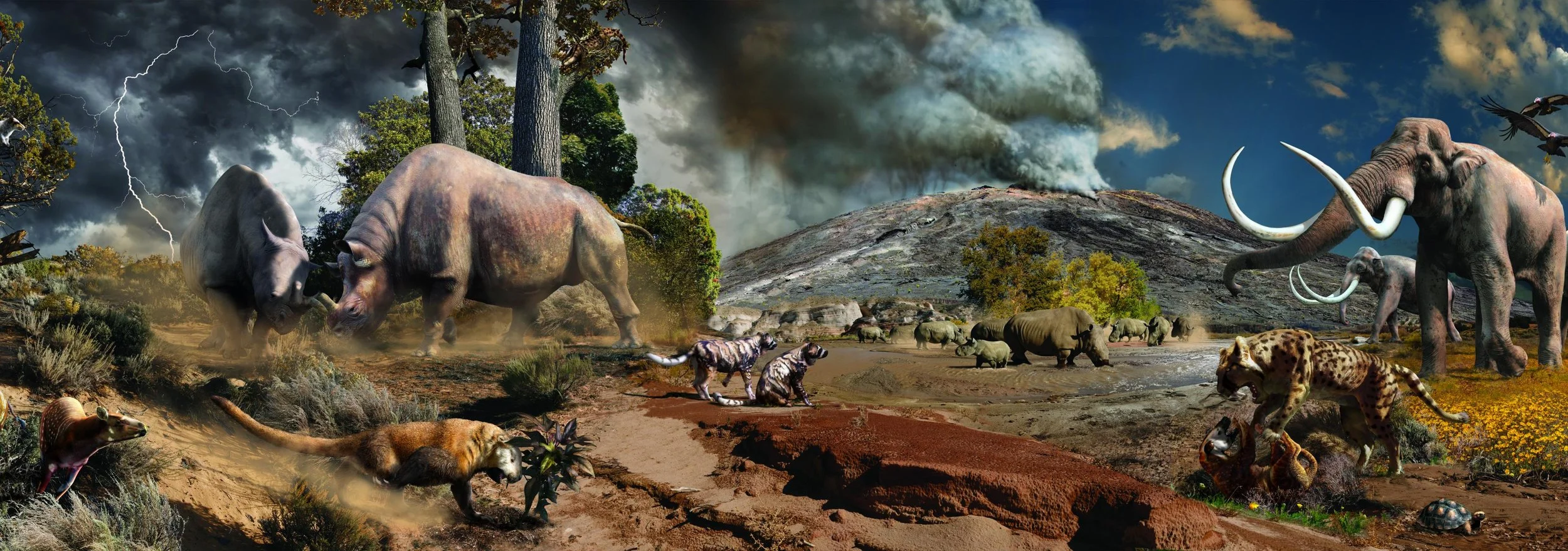
Volcanic Floodplain Environment
Choose an Environment to Explore
Julius Csotonyi & Alexandra Lefort

Julius Csotonyi & Alexandra Lefort

Hyracotherium: a primitive horse relative

NPS Photo / A. Atwater Carnivore tooth from the Canoe Formation

Dr. Ron Blakey

Coryphodon
Diversification of Mammals
The dinosaurs went extinct 65 million years ago. This mass extinction made way for a grand diversification of mammals. The Rocky Mountains continued their uplift to the west and sea level dropped even further as the continent rose. The ancient seaway that had previously divided North America during the time of the dinosaurs disappeared completely. The Big Bend region remained a large basin or “sunken block” that was filled with new silt, sand, and clay, preserving the bones of ancient mammals. From around 45 to 30 million years ago, Big Bend experienced many volcanic eruptions that laid down ash and lava. Mammals that thrived in Big Bend from 55 million to 10,000 years ago include a wide variety such as saber-toothed cats, primitive dogs, early lemur-like primates, huge rhino relatives, and even mammoths.
Geological Setting
-

Swampy Floodplains
As the Rocky Mountains continued their uplift, the seaway that previously covered the land no longer existed. The same river systems that meandered through the forested basin during the formation of the Black Peaks Formation continued to deposit sediments on top of the older Cretaceous rocks. From 55 to 45 million years ago sandy braided rivers deposited the mudstones and sandstones of the Hannold Hill and Canoe Formations. This river system was steeper and higher energy because of the continued uplift of the continent, leading to the deposition of coarse sands thick with crossbedding. Hippo-like mammals lived in the swampy floodplains along with alligators and turtles.
-

The Chisos Formation
Around 45 to 30 million years ago the Big Bend region experienced multiple episodes of volcanism interrupted by long periods of relative quiet. The Chisos Formation (and the Chisos Mountains) is a result of this volcanism. This widely variable formation includes lavas, tuffs, tuffaceous sandstone, clay, and conglomerates. Some of the magma produced at this time never made it to the surface; instead laccoliths, sills and dikes injected themselves into the surrounding, older limestone, only exposed after millions of years of erosion. Fossils found from this time are large mammals, turtles, and freshwater snails. The environment would have been similar to modern day Mount Saint Helens in the state of Washington, which supports a great diversity of mammal life.
-

Modern Day Landscape
20 million years ago the climate continued to cool and grasslands spread across North America. True seasons developed and the landscape would have looked very similar to modern day. Sheep-like mammals dominated the landscape while carnivores were never far from sight. The climate kept cooling and by 5 million years ago North America was in an ice age. Though the Big Bend region is far south and was never covered by ice, it still supported ice age animals like saber-toothed cats and mammoths.
Featured Fossils

1 Titanoides
Titanoides was a large bear-like mammal that existed in Big Bend at this time.
2 Phenacolemur
The squirrel-like Phenacolemur was closely related to primates and lived in trees, where it ate nuts and fruits. 43 million years ago, true primates related to modern lemurs and tarsiers thrived in the forested floodplains of Big Bend.
3 Dunnophis
Non-dinosaur reptiles were still found in and around Big Bend, including the turtle, Baena, and Dunnophis, the snake.
4 Hyracotherium
A tiny mammal that is closely related to horses but looks nothing like a modern horse. Instead of one toe with a hardened hoof, they had multiple, padded toes on each foot. It fed on shrubs and trees, unlike modern horses that primarily rely on grasses.
5 Stylinodon
Stylinodon was a bizarre bear-sized mammal with massive blunt teeth. It likely used its strong front limbs and sharp claws to dig for insects and roots.
6 Brontotheres
Ancient relative of the rhinoceros that lived around 45 million years ago. The biggest brontothere found in North America is called Megacerops, and has been found in Big Bend National Park. Megacerops had a huge horn on the front of its face that looked like a slingshot.
7 Unitacyon
Uintacyon was a primitive carnivore that lived in Big Bend 45 million years ago. This predator had a long body and a long tail that allowed it to live in trees and on the ground.

8 Epicyon
Epicyon lived in the Big Bend region during the Miocene, approximately 20-5 million years ago. Epicyon was a large carnivore that likely weighted 200-300 pounds and belonged to the “bone-crushing dogs” family (Borophaginae).
9 Moschodestes
Also alive at this time was Moschodestes, a small rhinoceros that thrived in the spreading grasslands.
10 Hysiops
The Hysiops was a sheep-like camel relative that lived around 20 million years ago. They were likely woodland and grassland browsers and were likely preyed upon by the saber-toothed cat, Machariodus.
11 Machariodus
Machariodus was the size of a modern-day tiger. Its long serrated canine teeth and powerful jaws allowed this predator to take down prey with one devastating bite.
12 Columbian Mammoth
This huge relative of the elephant was larger than its cousin, the woolly mammoth, and preferred grassland savannas to icy conditions.
13 Geochelone
While mammals ruled the landscape, reptiles like the land tortoise Geochelone still persisted.
Significance

Rooneyia, a rare fossil primate from the Big Bend region.
A Complete Depositional History
The Cenozoic fossil record exposed in Big Bend National Park is one of a kind. No other park has preserved such a complete depositional history of the past 65 million years. This amazingly complete record is helping scientists understand the timing of mammalian migration events in the past, as well as extinction events. By studying the impacts of climate change in the fossil record we are better suited to understand and adapt to our current climate challenges.
The presence of primates in the Big Bend fossil record is also unique. Primates went extinct in North America around 35 million years ago as the climate began significantly cooling. The last refuge for these lemur- and tarsier-like primates was Big Bend National Park. By the time primates made it to the warmer southern locations of Big Bend, they had gone extinct everywhere else in North America except Southern California. That makes the primate fossils from Big Bend and Southern California extremely important for understanding threats to primate conservation today.
Where to See The Rocks

Canoe Formation
The Canoe Formation is also best seen in the Tornillo Flats around the Fossil Discovery Exhibit, but on the western side of the road. The picturesque hoodoos and spires within Tornillo Flats are mainly composed of the Big Yellow Sandstone member of the Canoe Formation.

Hannold Hill Formation
The best place to see the Hannold Hill Formation is the Fossil Discovery Exhibit. This site is historically significant to the park because it was where mammal fossils were first discovered. The original Fossil Discovery Exhibit protected Coryphodon bones that were in place (or insitu) and allowed visitors to see a real fossil in the park rocks. The Fossil Discovery Trail takes you along the coarser sandstones of the Hannold Hill Formation and provides views of the colorful mudstones that have also yielded mammal fossils.

The Chisos Mountains
The remains of the ancient volcanic action that shook Big Bend 45 million years ago can be seen throughout the park. The Chisos Mountains are the best example of the explosive volcanic history of Big Bend. Pick a hike that starts in the Chisos Basin or the Lost Mine Trail to see the eruptive rocks up close. The intrusive rocks of the park such as sills, dikes, and laccoliths, can be seen all around the Chisos Mountains, especially as you drive towards Study Butte. The Grapevine Hills Trail leads you through an ancient magma body that slowly cooled underground, causing the distinct erosional features such as the balanced rock to form. Pyroclastic flows can be seen at the lower Burro Pouroff trail, and thick ash deposits can be seen at Tuff Canyon along the Ross Maxwell Scenic Drive.